ED262 mylineONLINE: Ethnicity, Race & Racism
647 views | +0 today
Follow
ED262 mylineONLINE:  Ethnicity, Race & Racism
View related curated articles on Flipboard / Ethnicity, Race, Racism at http://flip.it/ZoetKw  
Curated by Dennis Swender
Your new post is loading...
Scooped by Dennis Swender
Scoop.it!

Old Mexico lives on

Old Mexico lives on | ED262 mylineONLINE:  Ethnicity, Race & Racism | Scoop.it
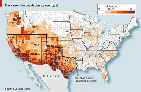
On February 2nd 1848, following a short and one-sided war, Mexico agreed to cede more than half its territory to the United States. An area covering most of present-day Arizona, California, Nevada, New Mexico and Utah, plus parts of several other states, was handed over to gringolandia. The rebellious state of Tejas, which had declared its independence from Mexico in 1836, was recognised as American soil too. But a century and a half later, communities have proved more durable than borders. The counties with the highest concentration of Mexicans (as defined by ethnicity, rather than citizenship) overlap closely with the area that belonged to Mexico before the great gringo land-grab of 1848. Some are recent arrivals; others trace their roots to long before the map was redrawn. They didn’t jump the border—it jumped them.


Tags: culture, demographics, North America, historical, colonialism, borders, political.

Alex Smiga's curator insight, August 10, 2017 6:51 AM
I say it all the time, culture does not respect boarders. 
Nicole Canova's curator insight, February 9, 2018 8:15 PM
Up until 170 years ago, a large portion of what is now the United States was actually controlled by Mexico.  Remarkably, this is still reflected in the ethnic makeup of the population of that area, which covers all or part of 8 states (all of California, Nevada, Utah, Arizona, New Mexico, and Texas, and part of Colorado and Wyoming).  Political borders may determine citizenship, but they are by no means a hard division of ethnicity or culture.
Scooped by Dennis Swender
Scoop.it!

Non-Native American Nations Control over North America

Non-Native American Nations Control over North America | ED262 mylineONLINE:  Ethnicity, Race & Racism | Scoop.it
Kevin Cournoyer's curator insight, April 8, 2015 1:33 PM

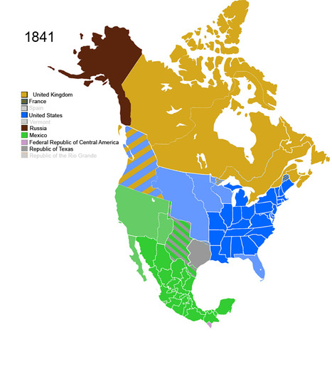
Wow. As a history major, I found this map timeline really interesting and really cool. It's a great example of how even though the physical geography of a place can remain the same, its political and economic geography can change so rapidly (or not so rapidly). It was especially interesting to see the brief stints that entities such as the Republic of the Rio Grande or the Confederate States of America did in the dividing up of North America over the last two and a half centuries. For someone who knows nothing about U.S. history, those blips on the radar beg the question, "what happened there?" How can a political entity encompass a geographic region and then disappear just as quickly?


And that ties into what I think this map is really about: colonialism. This map says a great deal about how European (or Western) empires carved up the New World and what some of their political or economic goals were in the times that the map shows. It's also important to note the title of the map: "Non-Native American Nations Control over North America". So as we see the map changing to show European or United States expansion, what we DON'T see is the gradual loss of land experienced by the various Native American tribes that inhabited the continent long before Europeans ever laid eyes on it. This map, therefore, highlights how political and economic geography can change so drastically when groups with a lot of economic, political, and military power are at odds with groups who are severely disadvantaged in these areas. 

Mark Hathaway's curator insight, September 17, 2015 9:00 AM

This map is an excellent resource in show the evolution of colonial claims to North America.. It is fascinating to watch all the political changes that have occurred on the continent in over the past 500 years. The biggest change is the evolutions of the United Sates from a small city state like nation to an empire on both the Atlantic and Pacific oceans. This is also an extremely sad story to be told from this map. The loss and destruction of Native Americans is next to slavery is  the greatest sin of America. This map tells the complex story of our Continent.  

Scooped by Dennis Swender
Scoop.it!

More Mexicans leave than enter USA in historic shift

More Mexicans leave than enter USA in historic shift | ED262 mylineONLINE:  Ethnicity, Race & Racism | Scoop.it
After four decades of mass migration to the U.S., more Mexicans are now returning home.
Gene Gagne's curator insight, December 1, 2015 9:44 PM

With less jobs now in the u.s. and the economic growth in Mexico this is a good reason for Mexicans to head back home. What people do not realize at least I did not is the fact that there is a lot of entrepreneurship on the streets of Mexico. Since 2000 the changes that have occurred in Mexico is economy, education, politics and lower birth rates. 

Matthew Richmond's curator insight, December 2, 2015 12:17 PM

The first thing I thought while I was reading this was "I wonder if Donald Trump, and his flock of moron followers have seen these statistics?" I mean, never let the truth get in the way of a good hate speech right?! But as I continued reading I couldn't help but worry about the effect this could have on the American economy. The truth is that illegal's do the work we aren't willing to do. Do you know any American kids who want to work in the fields of Alabama picking watermelon's for $5 an hour? Hell, do you know any American kids who want to work, period? Do I actually think a watermelon is worth $13?

John Puchein's curator insight, December 4, 2015 6:51 AM

Due to a Mexican economy rebounding and a slow down in the American economy making it harder to find jobs, we are seeing a change in Mexican immigration patterns. While this has been suspected for years, Pew research finalized a study.